Lore:Cheydinhal
| Cheydinhal | |
|---|---|
| Type | Settlement |
| Continent | Tamriel |
| Province | Cyrodiil |
| Region | Nibenay Basin |
| Appears in | Oblivion, ESO |


Cheydinhal is one of the nine major cities in the province of Cyrodiil, situated in the boreal highlands of the Nibenay Basin. Cheydinhal is an idyllic and prosperous Nibenese city that is noted for its heavily Dunmeri inspired culture and architecture, which came in nearly half a century before the Fourth Era. The city is known for its broad, green parkland and neatly trimmed cityscape, all of which surround the graceful willows of the Corbolo River.[1] Cheydinhal is also the home of House Tharn, an ancient Imperial family that has lived in the region since before the Empire's inception.[2]
Layout and Geography[edit]


Cheydinhal is built on the Blue Road, one of the main thoroughfares in the Imperial Province. It stretches between the temperate climate of the Heartlands and the misty alpines of the Nibenay Basin. It is surrounded by evergreen woodland and the steep foothills of the nearby Valus Mountains to the east. It also provides little flatland for any settlement as large as Cheydinhal. The closest is the small farming community in Harlun's Watch just south of the city or even estates across the county. While the exact border of the county is unclear, the area north between the city and the Jerall Mountains is part of Cheydinhal.[3]
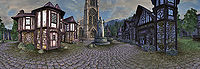
The city is split into three different districts, the land of Castle Cheydinhal, the Chapel District, and the Market District. They are separated by the banks of the Corbolo River and the willow trees that laden the river. The Market District lies on the west side of the river, and here is where all of Cheydinhal's commerce is located. It is complimented with a statue depicting Vanus Galerion, the founder of the Mages Guild. The Chapel District is located on the east side of the river and it contains both the Great Chapel of Arkay and the residential quarter. It is said that even the poorest citizens are bright and clean. To the north on the same side as the Market District is Castle Cheydinhal's courtyard and inner keep. Both sides are connected by bridges and the long park island in the middle of the river.[1]
Notable Locales[edit]
|
|
County Cheydinhal[edit]


County Cheydinhal is a region centered around the eponymous city in northeast Cyrodiil and is administrated by the Count of Cheydinhal. Like other counties in the province, its size is comparable to the holds in Skyrim,[5] but their borders have yet to be explicitly defined on any map. The northeast corner of Cyrodiil, between the county city, the Jerall Mountains and around Lake Arrius is one of the only known parts of County Cheydinhal.[3] Some notable locations in this area includes Azura's shrine, Hero Hill, the Shurgak Clan Estate, and White Fall Mountain.
At least some portion of this land is known as Outer Cheydinhal, and it has been controlled by House Tharn since the late First Era.[6] It was originally leased to them after General Turpis "Volte-Face" Tharn married Bendu Olo's niece at the end of the War of Righteousness.[2][6] Kingscrest Cavern is a chert and flint mine found in this region and it is owned by House Tharn vassals. By the mid-Second Era, it had long since been abandoned.[7]
There is another region east and south of the city called the Cheydinhal Foothills. It is a large portion of northeast Cyrodiil; between Blue Road Keep, the Reed River basin, and the hills around Kemen and Fort Scinia. The Order of the Black Worm built a dark anchor in this region, east of Cheydinhal.[8]
History[edit]
Early History and the Alliance War[edit]


Although there is evidence to suggest House Tharn has existed in the area since before the First Empire,[2] it is unknown when exactly the settlement nor the county was founded. Some of the earliest mentions of the settlement date back to the War of Righteousness circa 1E 2300s, when General Turpis Tharn became the Earl of Outer Cheydinhal.[2] At some point, Cheydinhal was caught in a conflict in the mid-Second Era and General Meric Renmus' tactical withdrawal from the city was studied by aspiring legionnaires of the Empire.[9]
When the Planemeld left Cyrodiil sundered and ruined in the sixth century of the Second Era, the Imperial garrison in Cheydinhal amassed control over the town and imposed themselves as tyrannical rulers, often forcing the people into slavery under them. They would also draft able-bodied people into their ranks whether they wanted to or not, and when they tried to draft a commoner, Donus Falto, he ran away into the wilderness and left his family devastated.[10]
That event sparked a large revolution led by Sylvian Herius and the people raised their arms against the Imperial Legion. In time, the town had been split by the Corbolo, with the west occupied by the rebels and the east controlled by the Legion. Another figure, Vyctoria Girien joined the resistance later and proved a capable leader, often coming at odds with Sylvian's authority.[11] By 2E 582, the Alliance War raged across central Cyrodiil, engulfing Cheydinhal in the conflict. Generally speaking, the ruins of the city was located in territory controlled by the Ebonheart Pact, but real power over the roads around Cheydinhal was determined by control over nearby Farragut Keep.[12] Every so often, wandering soldiers of the Alliances would travel to the city and assist the rebellion and uproot the Imperial Legion.
Clan Indarys and the Oblivion Crisis[edit]


Sometime in the fifth century of the Third Era, many Dark Elves traveled west from their ancestral homeland of Morrowind to distance themselves from the Temple theocracy. They were said to have been inspired by the patronage of Zenithar, which propagated the stimulating commercial atmosphere in Cyrodiil. Half a century later, one of these immigrants, Andel Indarys became the Count of Cheydinhal.[1] Sometime around 3E 413, the Count married Llathasa Indarys[13] and had a child with her, Farwil Indarys.
His sudden rise to the Cheydinhal nobility is hard to explain and most of the oldest Imperial families regarded him as a "presumptuous upstart."[1] Some of the other counts believed that he reached his position with help from Queen Barenziah and that he serves her.[13] When his wife was discovered on the steps of Castle Cheydinhal badly battered and later dead, it quickly turned Andel Indarys into a very controversial figure, and many rumors of suspicion, wrath, and infidelity began to follow him. It left several people, such as the writer, Alessia Ottus to believe a darker mystery was at play.[1]
When the Oblivion Crisis occurred in 3E 433, the Count enlisted the Knights of the Thorn, led by his son, Sir Farwil Indarys to vanquish the daedric horde from their domain. Their endeavor ended in failure, reportedly outnumbered by a hundred to one with only Farwil and Sir Bremman Senyan left surviving in the Deadlands. That was until the Hero of Kvatch delved into the Oblivion Gate and fought through the volcanic wastes with the two knights. It is unknown if they survived the ordeal but the gate was closed and Cheydinhal was saved.[14][15] The Count later offered their assistance to the Hero for the defense of Bruma by sending some soldiers.[16]
Happenings at the turn of the Third Era[edit]


Concurrent to the Crisis, many noteworthy events took place in Cheydinhal. For one, the famous painter, Rythe Lythandas went missing for several days, leaving his wife, Tivela grieving. Some rumored that Rythe was kidnapped by the Cheydinhal Guard and kept in for ransom.[17]
When an adventurer came to their place to investigate, they discovered that his canvas was a magical portal to a painted world created by the Brush of Truepaint. A thief stole the brush and delved deep into the painted forest and the only way they could escape was if they could find the brush. Rythe and the adventurer were able to escape.[18] The Black Horse Courier reported on the incident, but the Lythandas family did not comment on what exactly happened, nor told the name of the person that helped them.[17]
The Captain of the Guard, Ulrich Leland used his power to impose heavy taxes and extort people for their money. While the Count took no notice of these activities, the second-in-command of the guard, Garrus Darelliun did not take these actions lightly and collaborated with a traveler to thwart his corruption. The traveler talked to one of the citizens, Aldos Othran, who was thrown out of his home for not complying with the guard. He confronted the guard in front of his home and was subsequently killed for fighting back. The traveler talked with Garrus and another citizen, Llevana Nedaren, and each offered a solution to the situation, but it is unknown which method was used. In any case, Ulrich's schemes were foiled and Garrus was promoted to Captain of the Guard.[19]
At around the same time, Aurorans assaulted the chapel of Arkay and killed many people, including the Living Saint, Errandil. The Divine Crusader defeated the Aurorans and blessed the Sword of the Crusader at the altar in the chapel.[20]
Cheydinhal in the Fourth Era[edit]

Cheydinhal continued well after the end of the Third Era but faced tribulations when the floating city, Umbriel made its way toward the city from across the Valus Mountains. People from across the region such as the folk in Mountain Watch were escorted to Cheydinhal as the Umbriel zombies positioned themselves a few hundred yards from the city, just out of range from the ballistae and catapults. After a day of fighting, the people in the city were able to evacuate and head down the Blue Road toward the Imperial City. The Knights of the Thorn, led by Ilver Indarys helped the Imperial Legion escort the refugees, and after the crisis was resolved, the people of Cheydinhal returned to their homes.[21]
Emperor Titus Mede II had split his armies into three at the tail end of the Great War for what would become later known as the Battle of the Red Ring in 4E 175. General Jonna and her army of Nordic legionnaires were stationed near Cheydinhal before they reached the Red Ring Road and advanced south to the Niben River, where they met General Decianus' army in the west and completely surrounded the Imperial City.[22]
In the years closely following 4E 176,[23] the city often spawned travelers that would carry on to Riften, in Skyrim.[24] On the 1st of Hearthfire in 4E 189, Cheydinhal erupted into violence and chaos like other cities at the time. The Dark Brotherhood's sanctuary in Cheydinhal was left deserted in 4E 200 by the Keeper of the Night Mother, Cicero, the last remnant of the province's brotherhood.[25] Despite the past conflicts that crippled Cheydinhal throughout the years, by 4E 201 its most esteemed citizen, Rythe Lythandas continued to live out his days in the city, even supplying people with rare samples of Painted Troll Fat.[26]
Known Rulers[edit]
- The Second Era
- Unnamed Duchess of Cheydinhal[27]
- The Third Era
- Count Andel Indarys (fl. 3E 314 – 3E 433)[13][14]
Culture and Society[edit]


- For Imperial culture as a whole, see the: Culture section on the Imperial page.
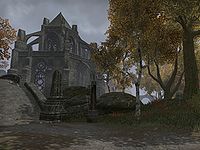
In 3E 431, the Elder Council mandated that the sale of spells throughout Cyrodiil should be re-distributed to separate guildhalls and that certain halls in the county cities should focus on a specific school. The Cheydinhal Mages Guild was the province's center for the School of Alteration,[28] at least up until the guild's dissolution in the Fourth Era. The city's patron divine is Arkay, the God of Life and Death and veneration for the deity takes place in the Great Chapel of Arkay in the city's chapel district.[1] The cathedral is the largest building in Cheydinhal and it can be seen from miles away.[21]
There is a play called the Legend of Krately House written by the playwright, Baloth-Kul that is based on a famous haunted house in Cheydinhal.[29] It is based on a real-world folktale that he happened upon in Cheydinhal, about a house that locals were certain was haunted. The story frightened him so much that it gave him the inspiration to create the script. By the time he had started his first draft, he was already in talks with the Actors Guild to see it performed on stage. Baloth-Kul claims that his story explains the layout of the original haunted house to a tee.[UOL 1]
Late in the First Era, a farmer outside of Cheydinhal discovered a large carrot of significant proportions, one that stood taller than a fully grown Breton. It was bought for an undisclosed amount of money by Emperor Brazollus Dor's castellan and turned into the centerpiece of a dish called Sinmur's Carrot. It was part of the third course in a feast hosted by Emperor Brazollus Dor, the feast of Saint Coellicia.[30] Cheydinhal is reportedly famous for its thirty-layered cake.[31]:174 Fibonaccus was a wizard from Cheydinhal that is most well-known for his attempt to animate the mermaid statue in Anvil and his conical hat that twisted into a spiral. Rumors have said that whenever Fibonaccus was surprised, the hat would unfurl and stand straight up.[32]
Dark Elf Diaspora[edit]
When the Dark Elves of Morrowind came to Cheydinhal, they brought a lot of their culture along with them, which shaped the city ever since.[1] For the longest time, Cheydinhal was built in the traditional Imperial style seen across central Cyrodiil,[12] but after the Dark Elves migrated into Cheydinhal, it soon took on aspects of their ornate architecture style.[1][33] Buildings were made half-timbered and given concave roofs similar to the ornate and traditional style seen in mainland Morrowind,[21] most notably with the former capital, Mournhold.
Not only did they bring their architecture, but they brought over their celebrations, such as the St. Jiub's Fair, which honors the eponymous saint of Morrowind, Jiub the Eradicator.[34] He was initially canonized by the Tribunal Temple for his crusade against the Cliff Racers.[35] By the late Third Era, Cheydinhal was ruled by a Dunmer family, Clan Indarys, whose crest depicts a tied thorny bramble.[36] For several generations, they have lived in Castle Cheydinhal with two family heirlooms, the Staff of Indarys and the Thornblade,[37] the latter of which serves as a symbol of the city's knightly order, the Knights of the Thorn.[38]
Gallery[edit]
-
Cheydinhal (ESO)
-
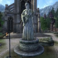
Statue of Arkay
-
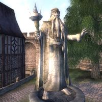
Statue of Galerion the Mystic
-
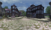
The Market District
-
The Chapel District
-
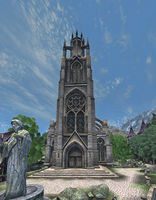
The Great Chapel of Arkay
-
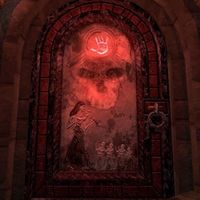
The Cheydinhal Sanctuary
-
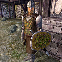
The Cheydinhal Guard
-
Cheydinhal Sapper (Legends)
-
Cheydinhal Conscript (Legends)


See Also[edit]
- For game-specific information, see the Oblivion and Elder Scrolls Online articles.
Books[edit]
- Guide to Cheydinhal by Alessia Ottus — An overview of Cheydinhal's people and notable places
- Legend of Krately House by Baloth-Kul — A play about the ghostly Krately family and how they died
References[edit]
- ^ a b c d e f g h i j k Guide to Cheydinhal — Alessia Ottus
- ^ a b c d House Tharn of Nibenay — Count Opius Voteporix
- ^ a b Map of Cyrodiil - The Elder Scrolls IV: Oblivion
- ^ a b The Elder Scrolls IV: Oblivion Official Game Guide — Peter Olafson
- ^ The Holds of Skyrim
- ^ a b Quickwater Cave loading screen text in ESO
- ^ Kingscrest Cavern loading screen text in ESO
- ^ Cheydinhal Foothills in ESO
- ^ Prefect Calo's dialogue in ESO: Dragonhold
- ^ Vyctoria Girien's dialogue in ESO
- ^ Sylvian Herius' dialogue in ESO
- ^ a b Cheydinhal location in ESO
- ^ a b c Rumors about Count Andel Indarys in Oblivion:Oblivion
- ^ a b The Wayward Knight quest in Oblivion
- ^ Cheydinhal Heir Saved!
- ^ Allies for Bruma story quest in Oblivion
- ^ a b Greatest Painter Safe!
- ^ A Brush with Death quest in Oblivion
- ^ Corruption and Conscience quest in Oblivion
- ^ The Sword of the Crusader story quest in Knights of the Nine
- ^ a b c Lord of Souls — Greg Keyes
- ^ The Great War — Legate Justianus Quintius
- ^ The Bear of Markarth — Arrianus Arius, Imperial Scholar
- ^ An Explorer's Guide to Skyrim — Marcius Carvain, Viscount Bruma
- ^ Cicero's Journal - Volume 4 — Cicero
- ^ Elgrim's dialogue in Skyrim
- ^ Basic Provisioning Guide — Cloelius Maluginensis
Supply Sergeant, Seventh Legion - ^ Mages Guild Charter
- ^ Legend of Krately House — Baloth-Kul
- ^ The Feast of Saint Coellicia III — Arfons Jellicandante, Expert on Nibenese Cuisine
- ^ The Infernal City — Greg Keyes
- ^ Fibonaccus Spiral Hat cosmetic description in ESO
- ^ Cheydinhal loading screen text in Oblivion
- ^ Burz gro-Khash's dialogue in Oblivion
- ^ Saint Jiub's Opus — Jiub
- ^ Cheydinhal Shield in Oblivion
- ^ Count Andel Indarys' dialogue in Oblivion
- ^ Banner of the Thorn Knights in Oblivion
Note: The following references are considered to be unofficial sources. They are included to round off this article and may not be authoritative or conclusive.